

Introducing Bluebeam Max
AI-Suprcharged Bluebeam Max - The Biggest Upgrade to Bluebeam Revu in Years
If you've been keeping an eye on what's happening in construction...
Whether the construction world is getting more complex and fast-paced, one aspect that will never change is accuracy. Tape measures and manual surveys no longer have a place in multimillion-dollar developments. In the current environment, the industry is being redesigned by digital accuracy and real-time information. We are witnessing a revolution that is led by 3D laser scanning (LiDAR) in construction.
This powerful technology is revolutionising how projects are planned, coordinated, and executed. Its ability to integrate seamlessly into construction workflows makes it more relevant than ever. According to a report by Research and Markets, the global 3D laser scanner market is valued at approximately $1.81 billion today. It is projected to reach $2.62 billion by 2029, growing at a CAGR of 9.7 %. This growth reflects the industry’s shift toward more thoughtful planning, more efficient management, and unparalleled precision.
From capturing every detail of a skyscraper’s structure to retrofitting ageing infrastructure and coordinating complex MEP systems, 3D laser scanning delivers the clarity needed to tackle even the most complicated projects.
In this article, we’ll explore the technology in detail, its connection to other digital innovations, and the practical ways your business can leverage it for a competitive edge.

Laser scanning in construction (also known as high-definition surveying (HDS), or reality capture), often referred to as LiDAR (Light Detection and Ranging), is the digital method of capturing physical spaces using laser beams. A laser pulse sent by the scanner 3d reflects off the surfaces. It is reflected back to the sensor to help estimate the accurate distance and spatial position of millions of points (to create a point cloud) in the surrounding environment.
All these points create a point cloud or, simply, a digital representation of the real world, which can then be rendered into elaborate 3D models. These models are used in planning, designing, constructing, and operating as well.
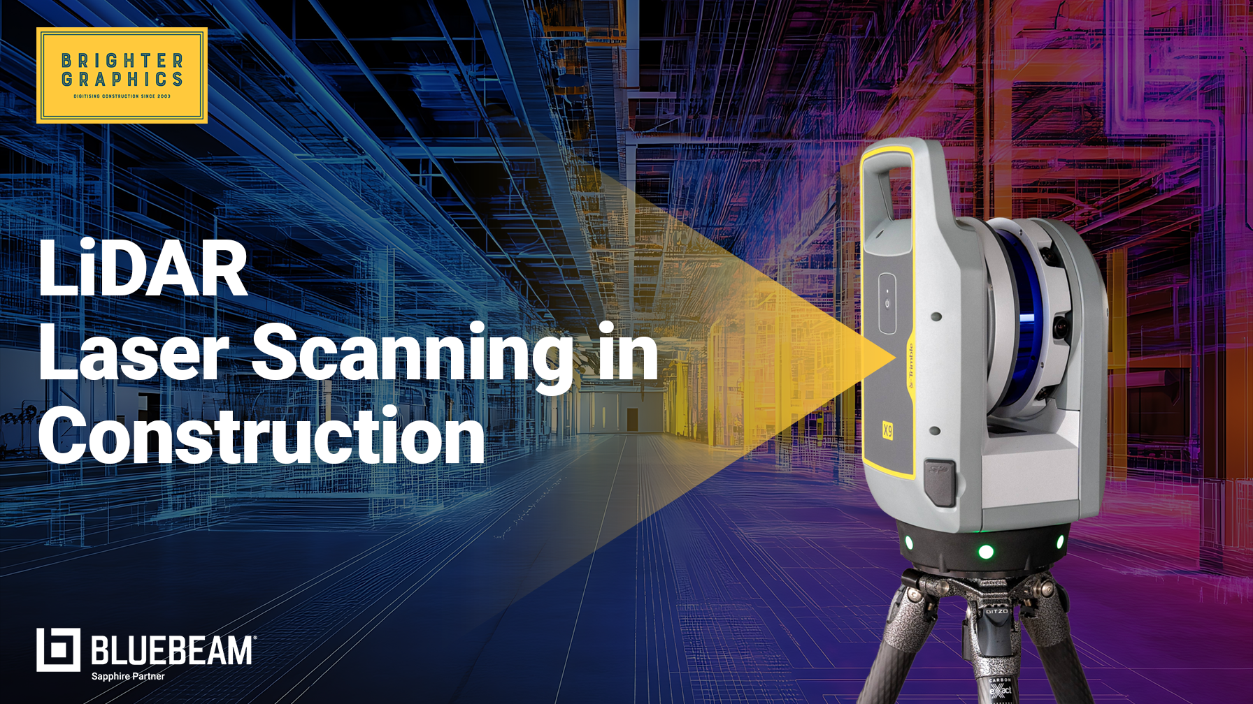
A great example of this technology in action is the Trimble X9. LiDAR technology, such as that used in the Trimble X9, is the most capable system for scanning buildings. It brings speed, accuracy, and flexibility to construction workflows with features like:
Such functionalities enable professionals to operate the scanner throughout the project life-cycle in a facilities-management process, including early design and post-construction periods.

Laser scanning can be a plug-and-play technology in theory, but in reality, it is a very complex technology. From the moment a laser pulse is emitted to the final 3D model in a BIM environment, each step plays an essential role in capturing accurate, usable data.
Here's a breakdown of how laser scanning works in practice—from laser emission and detection to post-processing:
The LiDAR scanner, which is placed on a tripod or a robotic platform, sends out a series of laser pulses at high frequency. These pulses hit conveyor belts and come back with a time stamp. By solving for the time of flight and angle, the scanner can find out the X, Y, and Z location of each reflection.
With millions of these coordinates being captured, the highly efficient program creates a dense digital map of the surroundings, a point cloud. This point cloud is a collection of spatial data points that represent a three-dimensional object or environment. The latest building laser scanners, such as Trimble X9, are equipped with the ability to produce a very high-density and highly accurate point cloud even in reflective and cluttered scanning conditions.
Operators can register scans using platforms such as Trimble FieldsLink even when they are still on location. This will make it sure:
The scans are imported into CAD/BIM tools, where they get further manipulated. Autodesk Revit and Trimble Connect can be used to process and model this data. The speed of project setup and coordination is possible through features such as auto-classification, geo-referencing, and object annotation.
In this end-to-end digital pipeline, scanning provides not only data but actionable data as insights ready to be used in making decisions.
The flexibility of the 3D building scan equipment is what makes it useful in many fields, for instance:
Using LiDAR-generated point clouds, architects perform the following actions:
This is especially beneficial to heritage sites, complex geometries, and renovation projects.
Laser scanning is an essential tool in the coordination of the trades. It enables:
By being combined with 3D scanner tools and BIM platforms, coordination will be easy and error-free.
After construction is complete, the scanning machines provide as-built records that are precise. These are the prerequisites to:
These are produced by a 3D laser scanner, long-range, which ensures unequalled durability and detail in a digital archive.
Laser scanning brings value far beyond just capturing measurements—it supports smarter decisions at every stage of a construction project. Here's how it enhances each phase from design to operations:
It is essential to be informed of the overall context during the design phase. Employing 3D building scanners comes down to the fact that:
This method eliminates the usual design and hopes it with evidence-based modelling.
In an active construction, scanning can be very useful to validate and plan:
Scanning also goes a long way in enhancing the mobility of the project team and eliminating the rework expenses.
Construction is not the final point in laser scanning. The next step is to leverage insightful data, which is used in:
Such understandings enhance efficient ROI on the whole useful life cycle of the building.
So, what makes 3 dimensional scanner technology so transformational in construction?
Laser scanning provides millimetre accuracy and therefore is very suitable for:
3D laser scanning equipment, unlike the manual methods, is less susceptible to manual errors and consistently provides accurate measurements of larger surfaces.
Recording 1 million points each second, LiDAR scanners reduce the time spent on-site and maximise output. This is helpful in cases where there is a safety or busy area, such as:
The shortened field time reduces disruptions and labour costs.
Conventional surveyors are usually exposed to ladders and lifts in confined spaces. Laser scanning, however:
This qualifies it as a priceless aid in brownfields redevelopment, industrial structures, and unsafe buildings.
The scans offer a picture of the present that can be:
Traditional blueprints or photos are significantly less detailed than the digital records.
The point clouds can be converted into.
This improves communication to all members of the project team, including engineers and clients.
When combined with Building Information Modelling (BIM), 3D building scanning services enable one to detect spatial conflicts before they are realised, thus too late. This includes:
Early detection of these issues will guarantee that projects are on time and on budget.
Nevertheless, like with many other fields, 3D laser scanning in construction companies is not completely barrier-free. To some construction companies, especially those in the process of transitioning between the old way of doing things, this might appear to be too much. And the key to fully accessing the benefits of this game-changing technology is to have an understanding of these challenges.
Professional-quality building 3D laser scanners are expensive to purchase. Consider the Trimble X9; it is a high-power and solid machine, but it is a big capital investment. Besides the scanning machine, companies have to invest in:
Such a consideration makes internal possession of 3D building scanning equipment extremely expensive to own by small and medium-sized contractors, especially when scanning is not a frequently demanded necessity.
Laser scanning is not a point-and-go situation. It demands skilled technicians who have knowledge of
Even trained surveyors should have specialised training to get used to this electronic workflow. Creating such a competency in-house will cost time, resources, and consistent education.
As much as a scanner allows almost all things visible to be digitally captured, familiarity with a physical site still plays an important role. The operators must:
A lack of understanding of the environment may cause the best 3d building scanner to create only part of the data or to create misaligned data.
The best news? All of these hurdles can be overcome easily. Some practical tips on how to introduce 3D laser scanning technology into your construction processes to make it work without making your team and budget balk.
Do not risk everything simultaneously. Instead, locate a particular billing unit in a current or future endeavour, like the installation of MEP systems or the documentation of an existing structure.
Advantages of pilot Roth scanning:
Monitor and record findings of the pilot to get a better process in coordination, fewer RFIs, and a decrease in change orders.
Fulfill the value potential by integrating the 3D laser outputs of scanners with your already established digital environment:
This combined process makes sure that scanned information does not stay siloed, but it is now an important component in the design, review, and construction process.
By collaborating with the experts, most of the above-listed challenges are eliminated. A reliable service provider is a trusted entity that brings:
Outsourcing enables the scalability of capabilities and negates capital costs and overhead training costs.
Discover how Brighter Graphics’ Digital Engineering service helps you adapt to digitising construction by handling laser scanning and BIM modelling for your next project.
To get a proper understanding of the capabilities of laser scanning during construction, we will consider how this technology was applied to simplify one of the most complicated types of projects, building an airport.
One of the major new expansions of an international airport. The catch? The airport also had to be fully operational, and the flights and passenger movements could not be affected during the project. The seconds counted.
The traditional survey presented a number of risks:
The materials were supplemented with Trimble X9 LiDAR scanners and autonomous vehicles to gather as-built information effectively.
Some of the key techniques were as follows:
By employing autonomous platforms, the area could be covered as quickly as possible, and the human presence could be reduced in crowded or complex places.
The net effect was instant and quantifiable:
The case highlights the fact that 3D laser scanning is not only accurate but also transformative.
At Brighter Graphics, we are not just scanning buildings, but we are providing clarity, speed, and assurance on your construction lifecycle. This is why our services are used by construction professionals all around the UK and beyond:
Our skilled team is headed by experienced professionals, Matt and Wes. Our team has 50 years of combined experience in the industry, as follows:
We have the best of both, interpreting the field and the model.
We use the Trimble X9, which is one of the most sophisticated LiDAR scanners in the market. Combined with:
We can match our service to your project, no matter whether you are doing one building or a whole development. Partnering with the Digital Engineering team at Brighter Graphics, you can expect:
We enable:
By partnering with Brighter Graphics, you will not only receive a scan but you will gain a scalable solution that is smarter, safer, and more efficient.
Laser scanning in construction is not an option anymore; this is a mandatory first step towards digitising construction that companies need to have in order to stay competitive, minimise their reworks, and deliver their projects with confidence. With the ability to map the current state of construction to the capabilities of identifying collisions and digital twins, the assets are manifold and well-established.
With the help of technologies, such as the Trimble X9, integrating with BIM tools, and working with trusted professionals in the industry, you can clarify and bring precision in every phase of your projects.
Connect with Brighter Graphics today and let us run a pilot scan of your present project milestone and demonstrate the ROI in real time.
Feel free to explore our Digital Engineering solutions today and request a proposal. This is where construction digitisation starts.
The digital is the future of construction. Let us construct it, well, and wisely, and economically.
If you've been keeping an eye on what's happening in construction...
At Brighter Graphics, we proudly announce our continued recognition as a Bluebeam Sapphire Partner for 2026, marking the second consecutive year...
By 2026, the global construction market will enter a significant paradigm shift, characterised by precision, data-driven processes, digital twins,...